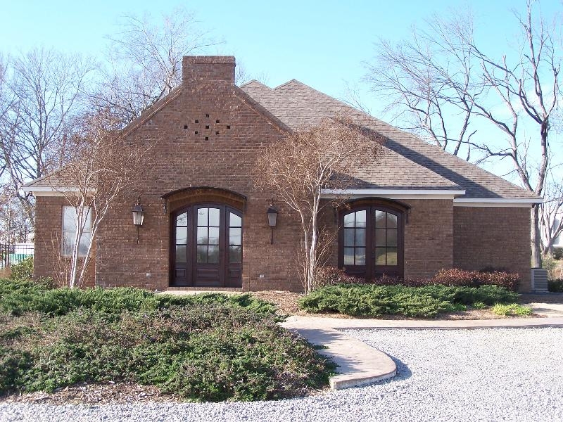
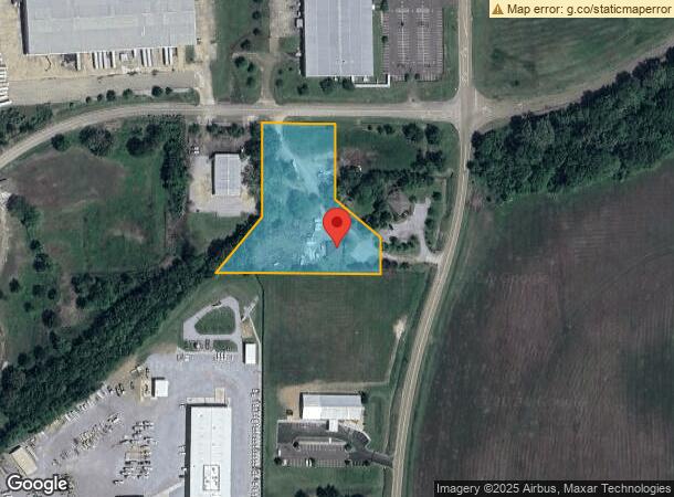
Property Record
168 Watford Park Way Dr, Canton, MS 39046
NEARBY LISTINGS FOR SALE OR LEASE
-
-
View all Canton listings for sale on LoopNet.com
Property Detail
168 Watford Park Way Dr
092H-27-015-03-00
2.9 AC IN NW1/4 SE1/4
Officebuilding
Madison
X
Mississippi
28089C0405G
2.90 AC
2024
Outlying Madison County
2024
Jackson
030403
Jackson, MS
1,860 SF
DEMOGRAPHICS near 168 Watford Park Way Dr
1 Mile
3 Mile
5 Mile
2024 Total Population
124
10,034
20,585
2029 Population
132
10,536
21,667
Pop Growth 2024-2029
+ 6.45%
+ 5.00%
+ 5.26%
Average Age
36
36
37
2024 Total Households
46
3,841
7,598
HH Growth 2024-2029
+ 6.52%
+ 5.21%
+ 5.37%
Median Household Inc
$94,230
$29,680
$42,754
Avg Household Size
2.60
2.50
2.60
2024 Avg HH Vehicles
2.00
1.00
2.00
Median Home Value
$273,683
$130,830
$195,120
Median Year Built
2010
1986
1991
Nearby Places
- Restaurants
- Banks
- Shops
- Fitness
- Groceries
PUBLIC TRANSPORTATION
AIRPORT
Jackson-Medgar Wiley Evers International
DRIVE
WALK
Distance
Jackson-Medgar Wiley Evers International
43 min
29.6 mi
Freight Ports
Port of Greater Baton Rouge
DRIVE
WALK
Distance
Port of Greater Baton Rouge
225 min
199.6 mi
SALE & LEASE HISTORY
LISTING DATE
SALE/LEASE

Feb 24, 2021
For Sale
Nearby Properties
Address
Land Use
TOTAL SIZE
Lot Size
Zoning
Address
Land Use
TOTAL SIZE
Lot Size
Zoning
1,900,835 SF
80.64 AC
Address
Land Use
TOTAL SIZE
Lot Size
Zoning
20,308 SF
316.50 AC
Address
Land Use
TOTAL SIZE
Lot Size
Zoning
1 SF
295 AC
I1
Address
Land Use
TOTAL SIZE
Lot Size
Zoning
1,466,000 SF
Address
Land Use
TOTAL SIZE
Lot Size
Zoning
363 SF
38.34 AC
P1
Address
Land Use
TOTAL SIZE
Lot Size
Zoning
65,378 SF
6.89 AC
Address
Land Use
TOTAL SIZE
Lot Size
Zoning
78,671 SF
29.79 AC
Address
Land Use
TOTAL SIZE
Lot Size
Zoning
162,676 SF
9.30 AC
Address
Land Use
TOTAL SIZE
Lot Size
Zoning
3,178 SF
74.38 AC
I2
Address
Land Use
TOTAL SIZE
Lot Size
Zoning
51,919 SF
7.91 AC
Address
Land Use
TOTAL SIZE
Lot Size
Zoning
73,843 SF
3.90 AC
I1
Address
Land Use
TOTAL SIZE
Lot Size
Zoning
9,788 SF
59 AC
R1
Address
Land Use
TOTAL SIZE
Lot Size
Zoning
100,297 SF
12.10 AC
Address
Land Use
TOTAL SIZE
Lot Size
Zoning
85,104 SF
23.80 AC
Address
Land Use
TOTAL SIZE
Lot Size
Zoning
31,976 SF
Address
Land Use
TOTAL SIZE
Lot Size
Zoning
6,518 SF
12.27 AC
Address
Land Use
TOTAL SIZE
Lot Size
Zoning
41,462 SF
2 AC
Address
Land Use
TOTAL SIZE
Lot Size
Zoning
100,019 SF
15 AC
Address
Land Use
TOTAL SIZE
Lot Size
Zoning
40,073 SF
2 AC
Address
Land Use
TOTAL SIZE
Lot Size
Zoning
1,027 SF
7.40 AC
R3
Address
Land Use
TOTAL SIZE
Lot Size
Zoning
24,140 SF
5.34 AC
Address
Land Use
TOTAL SIZE
Lot Size
Zoning
1,697 SF
9.25 AC
R3
Address
Land Use
TOTAL SIZE
Lot Size
Zoning
1,496,000 SF
117 AC
I2
Address
Land Use
TOTAL SIZE
Lot Size
Zoning
2,854 SF
7.90 AC
R3
Address
Land Use
TOTAL SIZE
Lot Size
Zoning
28,096 SF
1.86 AC
Address
Land Use
TOTAL SIZE
Lot Size
Zoning
46,105 SF
14.34 AC
Address
Land Use
TOTAL SIZE
Lot Size
Zoning
30,182 SF
2.08 AC
The World's #1 Commercial Real Estate Marketplace
Connect with us
© 2025 CoStar Group
The information above has been obtained from sources believed reliable. While we do not doubt its accuracy we have not verified it and make no guarantee, warranty or representation about it. It is your responsibility to independently confirm its accuracy and completeness. Any projections, opinions, assumptions, or estimates used are for example only and do not represent the current or future performance of the property. The value of this transaction to you depends on tax and other factors which should be evaluated by your tax, financial, and legal advisors. You and your advisors should conduct a careful, independent investigation of the property to determine to your satisfaction the suitability of the property for your needs.